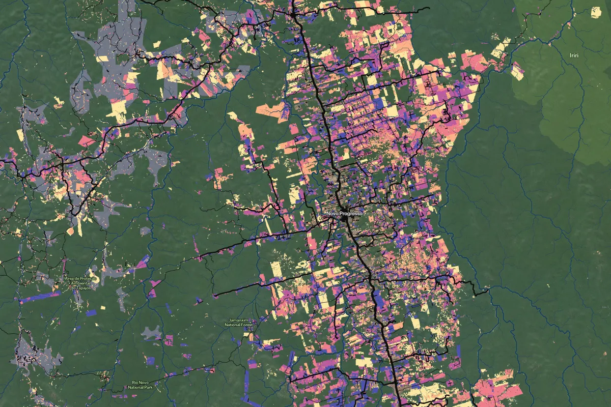
37° 48' 15.7068'' N, 122° 16' 15.9996'' W
MODERN MAP MAKING HAS ARRIVED
37° 48' 15.7068'' N, 122° 16' 15.9996'' W
MODERN MAP MAKING HAS ARRIVED
37° 48' 15.7068'' N, 122° 16' 15.9996'' W
MODERN MAP MAKING HAS ARRIVED
37° 48' 15.7068'' N, 122° 16' 15.9996'' W
MODERN MAP MAKING HAS ARRIVED
37° 48' 15.7068'' N, 122° 16' 15.9996'' W
MODERN MAP MAKING HAS ARRIVED
37° 48' 15.7068'' N, 122° 16' 15.9996'' W
MODERN MAP MAKING HAS ARRIVED
37° 48' 15.7068'' N, 122° 16' 15.9996'' W
MODERN MAP MAKING HAS ARRIVED
37° 48' 15.7068'' N, 122° 16' 15.9996'' W
MODERN MAP MAKING HAS ARRIVED
37° 48' 15.7068'' N, 122° 16' 15.9996'' W
MODERN MAP MAKING HAS ARRIVED
37° 48' 15.7068'' N, 122° 16' 15.9996'' W
MODERN MAP MAKING HAS ARRIVED
Maps
Editorial
Felt for investigative journalism: mapping Malaysian deforestation
Macaranga, a Malaysian publication about sustainability, leveraged Felt to produce an interactive story about deforestation.

Yao-Hua Law is an environmental journalist based in Malaysia. In 2019, he teamed up with a writer and editor SL Wong to launch Macaranga, a publication that covers the environment and sustainability in Malaysia.

The team uses a lot of data in his work, and geospatial context is crucial for telling his stories. This is why mapping has become an integral part of his reporting process. Yao-Hua Law uses a variety of tools, including Felt, QGIS, and Mapbox.

In recent months, Felt has become an indispensable part of his workflow because it helps the team to collaborate on maps while gathering all the data for the article and then, after the final version is embedded on the website, it gives readers an opportunity to explore the map on their own across different zoom levels.

Protecting Malaysian forests

Malaysia is one of the top mega-biodiversity hotspots, and it still has a lot of forest cover. Although it is a small country, it is quite well-developed, with one of the more advanced economies in the region. “We are in quite a good spot to be able to protect a lot of the forest. And we are still at a junction when we can make timely decisions about how we want to use our forest,” says Yao-Hua Law. He and his colleague asked readers to vote on the topics Macaranga should cover, and forest preservation was a leader, so he decided to investigate it.

Even though within peninsula Malaysia, 85% of the forests are forest reserves. However, logging and mining is legal in some of these reserves, and sometimes they are even used for farms or oil palm plantations. Yao-Hua Law set out on a mission to investigate the discrepancy between forest loss detected by satellites and official data released by the government. His investigation was published as a two-part series: Navigating the Multiverse of Forest Data and Projects that Replaced Natural Forests in Peninsular Malaysia, both featuring Felt maps.

Macaranga used Felt to create a forest reserve map that is free, online, and public using data from the Department of Environment. Currently, there are public maps created by the department and data accuracy provided by this organization can't be verified.

Mapping deforestation data

To kick things off, Yao-Hua Law decided to compare government data about forests in the peninsula with imagery provided by satellites. He looked annual reports published by the Department of Environment (DOE) and for the satellite data, he referred to the Global Forest Watch.

After analyzing these two dataset in QGIS, Yao-Hua Law determined which years were marked by the highest rate of tree loss and which states had the most tree loss based on satellite data. He also found out which states had the biggest gap between satellite-reported data and government reported data.

Then, he added development projects within forest reserves that were approved by the government hoping that he will be able to compare and match the area of each project with the tree loss around that project. “The first thing for us to really get the hang of or to confirm is whether the method or the approach actually works,” adds Yao-Hua Law.

Getting inputs from scientists and the local community

Reporting a complex story about the environment often requires interviewing with other journalists and engaging scientists and local community representations. “Felt has been a game-changer for us in terms of collaboration,” says for Yao-Hua Law. He uses it to share maps with his colleagues and speakers and to draw on them during interviews.

After the majority of analysis work is done, the reporter uploads data into Felt to share it with experts. “Recently, we were interviewing flood researchers, forest ecologists, and other experts, we were all looking at the same Felt map to make sense of the data about development projects that we see and understand their impact on the forest,” adds Yao.

Felt also helped the Macaranga team sketch out another story — this time, reporters interviewed people living along the the proposed route of the Petaling Jaya Dispersal Link highway (PJD). Felt allowed the reporters to share survey results and visualize the locations of the interviews. The maps shows if local community members supported the development or not, and also made it easy for the team to put photos they took along the route onto the map.

FELT HELPED THE MACARANGA TEAM MAP SURVEY RESULTS SHOWING HOW LOCALS PERCEIVE THE HIGHLY CONTESTED PETALING JAYA DISPERSAL LINK HIGHWAY (PJD).

Presenting the final result

Yao's dedication to investigating deforestation has led him to uncover some interesting findings. For instance, in the last twenty years, forest plantation has become the main driver of deforestation in Malaysia, replacing oil palm plantations.

The federal Department of Environment did not respond to Macaranga's request for a complete list of approved projects. However, the team was able to filter through 9,012 environmental impact assessment (EIA) reports to find development projects approved between July 2001 and June 2021, located within mature forests, and categorized them (forest plantation, mines, logging, etc.) based on their titles.

To finalize the project and present it to the audience, Yao-Hua Law used Felt to visualize different categories of commercial projects inside Malaysian forests so the readers can explore their area and learn more about the location of these developments, their type, approval date, etc.

For the PJD story, Yao-Hua Law took a Felt map consisting photos taken along the proposed highway and since Felt provides the coordinates, it was easy for him to code the final version of the story in Mapbox so the photos appear in the right place as the reader scrolls through the map. To learn more about the final result, check out his story here: Voices Along An Elevated Highway.

“Felt has been a game-changer for us in terms of collaboration.”
Bio
LinkedIn
More articles

Cartography Tips for Designing Web Maps

Search, filter, select — data discovery done right

Getting the most out of Felt’s new Workspaces

Teaching Spatial Analysis with Felt

Powerful new admin tools and a streamlined billing experience

Three key UI upgrades in Felt 2.0