37° 48' 15.7068'' N, 122° 16' 15.9996'' W
cloud-native gis has arrived
37° 48' 15.7068'' N, 122° 16' 15.9996'' W
cloud-native gis has arrived
37° 48' 15.7068'' N, 122° 16' 15.9996'' W
cloud-native gis has arrived
37° 48' 15.7068'' N, 122° 16' 15.9996'' W
cloud-native gis has arrived
37° 48' 15.7068'' N, 122° 16' 15.9996'' W
cloud-native gis has arrived
37° 48' 15.7068'' N, 122° 16' 15.9996'' W
cloud-native gis has arrived
37° 48' 15.7068'' N, 122° 16' 15.9996'' W
cloud-native gis has arrived
37° 48' 15.7068'' N, 122° 16' 15.9996'' W
cloud-native gis has arrived
37° 48' 15.7068'' N, 122° 16' 15.9996'' W
cloud-native gis has arrived
37° 48' 15.7068'' N, 122° 16' 15.9996'' W
cloud-native gis has arrived
Maps
Product
Integrate and automate: power your apps with Felt's API and Python SDK
Setting up a custom geospatial app shouldn't take a dedicated development team, and years of effort.

Every day we see our users build more and more innovative geospatial solutions with Felt. From sending live data updates to their sales teams, to powering external apps with data drawn in Felt, our users are consistently producing custom solutions to drive their businesses.

Today, we’re excited to announce three major updates to help companies and organizations of all sizes integrate Felt into their data workflows:

  • A new API with enhanced capabilities such as refreshing live data layers, creating and updating elements or listening to map updates via webhooks.
  • A documentation site with follow-along guides, an exhaustive API reference and built-in testing features.
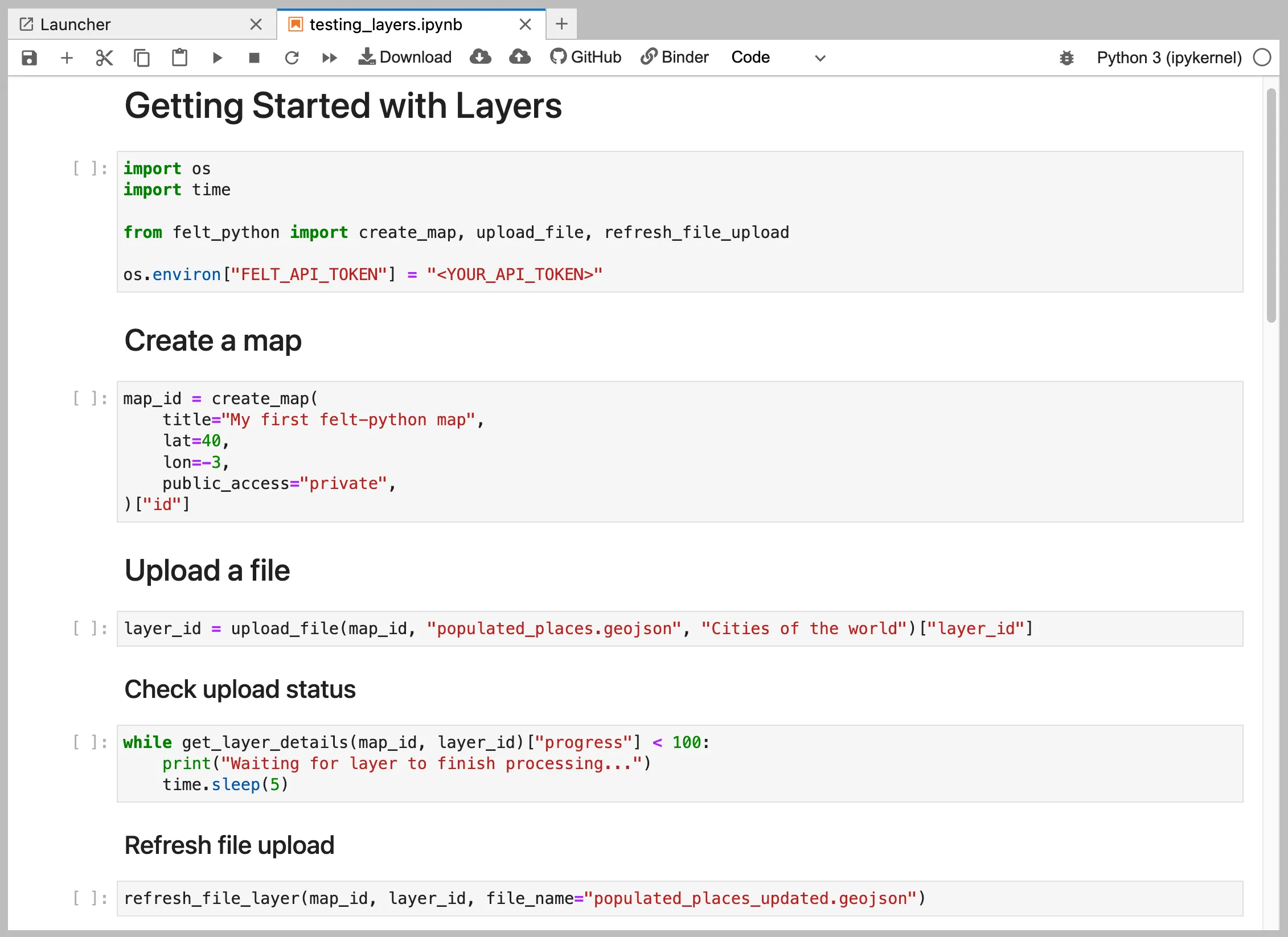
  • A Python SDK, so that GIS and data professionals can continue to work in their preferred tools.

These new tools make it easy to create the custom apps you need to accelerate any spatial workflow, without requiring additional staffing or technical expertise to complete the job. Plus, security and outstanding performance are built in, so your team can stay focused on your business roadmap, instead of maintenance. Check it out:

Powerful new API

Felt's new API offers powerful features to streamline geospatial data management and integration. Here's a quick overview of its key capabilities:

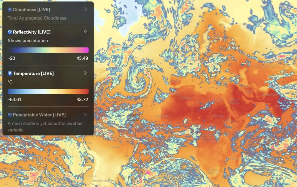
  • Data Management: Easily create, delete, style, and refresh data layers to keep your maps current and visually appealing.
  • Workspace Organization: Efficiently manage your maps and library layers for consistent and organized projects.
  • Element Control: Create, delete, and update map elements to maintain accurate and dynamic visualizations.
  • Real-Time Notifications: Use webhooks to receive real-time updates and automate workflows based on changes in your maps.

In the field with the new API

Our users are already making great use of the new API. Take the case of Terrabotics, a UK-based Space to Earth Analytics company that is using Felt to provide users with interactive tools to gather oil & gas intel and monitor industrial gas emissions.

Meanwhile, Brimstone is on a mission to provide the world with deeply decarbonized cement, and is making use of Felt’s API to keep their reference maps always fresh.

Damon and Kyle won our internal API hackathon with this stunning dashboard of live weather data.

Comprehensive documentation

Accompanying our API release is a brand-new documentation site. We understand the importance of clear, comprehensive documentation in enabling developers to harness the full potential of our platform.

Our goal is to provide developers with all the resources they need to seamlessly integrate Felt into their workflows. Whether you're a seasoned developer or just getting started with geospatial applications, our documentation portal is your gateway to unlocking the power of Felt.

"With Felt's API solution, maintaining better, high-quality maps takes less time for us" - Erwin Kuhn, Software Engineer at Brimstone

Faster integration with our Python SDK

To further simplify integration, we're launching a Python library designed specifically for interacting with Felt's API. Python developers can now leverage Felt's capabilities using familiar syntax and conventions, reducing development time and effort. Installation is as simple as running:

pip install felt-python

The library provides convenient abstractions for common API workflows, such as uploading a file or DataFrame from a Jupyter notebook in a single function call.

Try it out today

Felt is committed to empowering developers to build innovative, collaborative, and efficient geospatial applications. Explore our API, dive into our Python library, and discover the possibilities with our new documentation portal. Want to start? Get going by creating an API token.

We're always eager to hear your thoughts — feel free to send us your feedback at support@felt.com.

"This new “Refresh” option is brilliant and highly appreciated when I do our weekly updates of our many layers on Monday!" - Gareth Morgan, Founder and CEO at Terrabotics
Bio
LinkedIn
More articles

Introducing the new Team plan

Better together — our ongoing commitment to QGIS

Case Study: How Sharetown tackles logistics with Felt