


Felt gives map developers and app builders the tools to create powerful, cloud-native apps without the complexity of traditional GIS software.

Use Felt’s SDK to embed interactive maps into your own web apps and dashboards, making GIS app development faster and easier for every map developer.
Design rich popups, sidebars, and modals that deliver key insights instantly, giving map developers and app builders complete control over user experience in GIS app development.


Extend Felt with custom capabilities that let map developers and app builders build faster. From AI-powered workflows to tailored features, Felt is the location-based app builder that adapts to your needs.
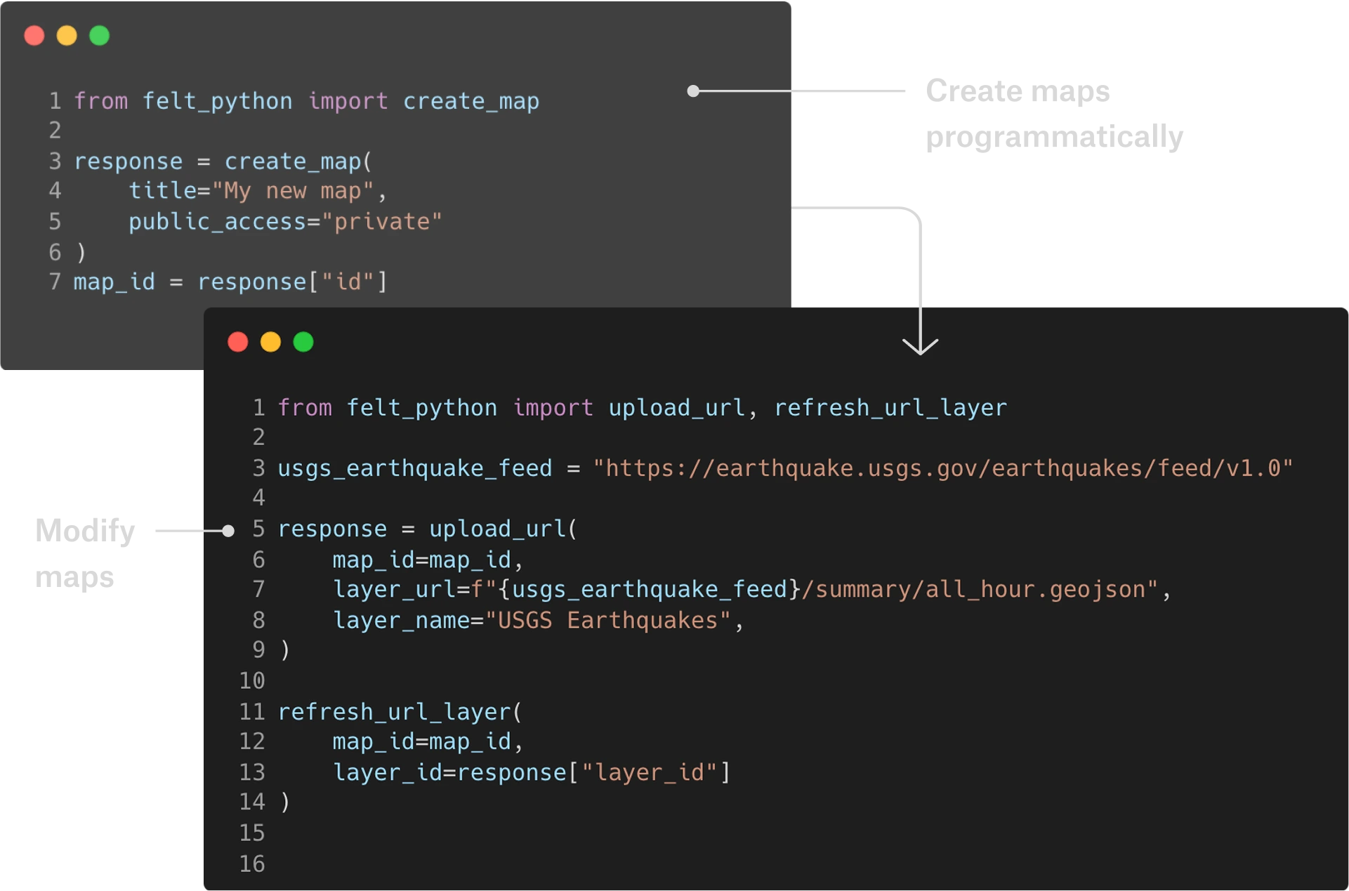
Felt’s REST API lets map developers and app builders integrate powerful GIS features directly into their workflows. Whether you’re building dashboards or a location-based app builder, automation is seamless.


GIS application development refers to creating software applications that work with Geographic Information Systems (GIS) to capture, store, analyze, manage, and display geospatial data. These applications help users visualize and interact with location-based information through maps, charts, and other geographic representations.
Felt's GIS software makes it easy to build and ship applications with these capabilities.
Map developers can build GIS applications using various technologies and frameworks. Web-based applications often use JavaScript libraries like Leaflet, OpenLayers, or Mapbox GL JS, combined with mapping services from providers like Google Maps, Felt, or OpenStreetMap. Unlike desktop-based tools, these applications scale with your data.
Felt's advanced app builder solution makes it easy ship location-based applications natively, or hosted on Felt.
Felt's location-based app builder is enhanced with AI and cuts deployment times by 75% by allowing users to build spatial applications with just a prompt rather than requiring extensive coding. Users can simply describe what they want directly in the map, and watch as their spatial conversations turn into tools. This eliminates the need for specialized programming skills that traditional GIS app development typically requires.
Felt's cutting-edge GIS app development software is cloud-native and eliminates traditional infrastructure requirements, allowing developers to focus on building applications rather than managing servers and deployment pipelines.
The platform combines AI-powered app building capabilities with comprehensive developer tools, including REST APIs, JavaScript SDK, and Python modules, all accessible through natural language prompts and full programmatic control for custom implementations.
Map developers can leverage Felt's JavaScript SDK to build custom experiences and embed Felt maps into their own applications with full programmatic control using Felt's Developer Tools. This modern approach to GIS app development transforms what was traditionally a complex, time-intensive process requiring specialized expertise into an accessible platform where developers can rapidly prototype, build, and deploy sophisticated spatial applications with minimal overhead.
Felt supports an extensive range of data formats and integrations for GIS app building, making it highly flexible for diverse development needs. Felt supports all formats of vector data including File Geodatabase, Shapefile, Geopackage, KML, GeoJSON, OSM PBF, CSV, and many more, with files up to 5GB in size.
Felt integrates directly with Postgres/PostGIS, Snowflake, Databricks, S3, BigQuery, Redshift, Esri Feature Service, Google Cloud Platform and STAC. Users can connect any cloud source to keep location data up-to-date and ensure teams always work from the source of truth.
Felt's comprehensive format support combined with real-time database connections and flexible export options makes Felt particularly well-suited for app building scenarios where developers need to integrate diverse data sources and maintain live connections to operational databases.
