37° 48' 15.7068'' N, 122° 16' 15.9996'' W
cloud-native gis has arrived
37° 48' 15.7068'' N, 122° 16' 15.9996'' W
cloud-native gis has arrived
37° 48' 15.7068'' N, 122° 16' 15.9996'' W
cloud-native gis has arrived
37° 48' 15.7068'' N, 122° 16' 15.9996'' W
cloud-native gis has arrived
37° 48' 15.7068'' N, 122° 16' 15.9996'' W
cloud-native gis has arrived
37° 48' 15.7068'' N, 122° 16' 15.9996'' W
cloud-native gis has arrived
37° 48' 15.7068'' N, 122° 16' 15.9996'' W
cloud-native gis has arrived
37° 48' 15.7068'' N, 122° 16' 15.9996'' W
cloud-native gis has arrived
37° 48' 15.7068'' N, 122° 16' 15.9996'' W
cloud-native gis has arrived
37° 48' 15.7068'' N, 122° 16' 15.9996'' W
cloud-native gis has arrived
Island-like shape.
The most trusted mapping platform for collaborative teams.
  • Connect with a Felt expert who will understand your team’s unique mapping needs.
  • Explore the full capabilities of the Felt platform
  • Get tailored guidance on how to deploy custom map solutions.
Felt is trusted by over 1,000 companies globally:
Request a demo today:
Satellite view
Felt comes with a rich basemap and a beautiful, high-resolution satellite imagery. And if you have your own, using your basemap is simple.
Request a demo
Collaboration and Teamwork Built In
Felt works great with teams. Sharing is as simple as it is powerful. You can add a coworker to map with a link. It’s easy to set defaults for access, and there are granular options. And yes, it supports real-time, multiplayer collaboration.
Request a demo
Rich API, Easy to use API
Felt works great with your existing tooling with a programmatic API. You can add data, upload layers, and even listen for live updates via webhooks. And of course, there are SDK for Python and JavaScript.
Request a demo
Build Custom Apps with a JavaScript SDK
Felt comes with a rich JavaScript SDK to customize your map any way you want. You can hide any part of the UI, build custom maps that load your data in popups, or even built interactive, branded maps.
Request a demo
Get Insights via Dashboards
Your data comes alive with Felt. Get the insights you want without having an engineer. You can quickly build a live-updating, interactive dashboard that works with your geospatial data. You can use bar charts, histograms, and even measure distances live.
Request a demo
Upload Anything, even Terabytes of Data
Felt works with (almost) any type of data. You can add geospatial formats, as well as generic formats like Excel, CSVs or even zipped files. It works with raster formats, vector formats, and even can download from URL sources.
Request a demo
You own your data, we keep it secure

Best-in-class protection

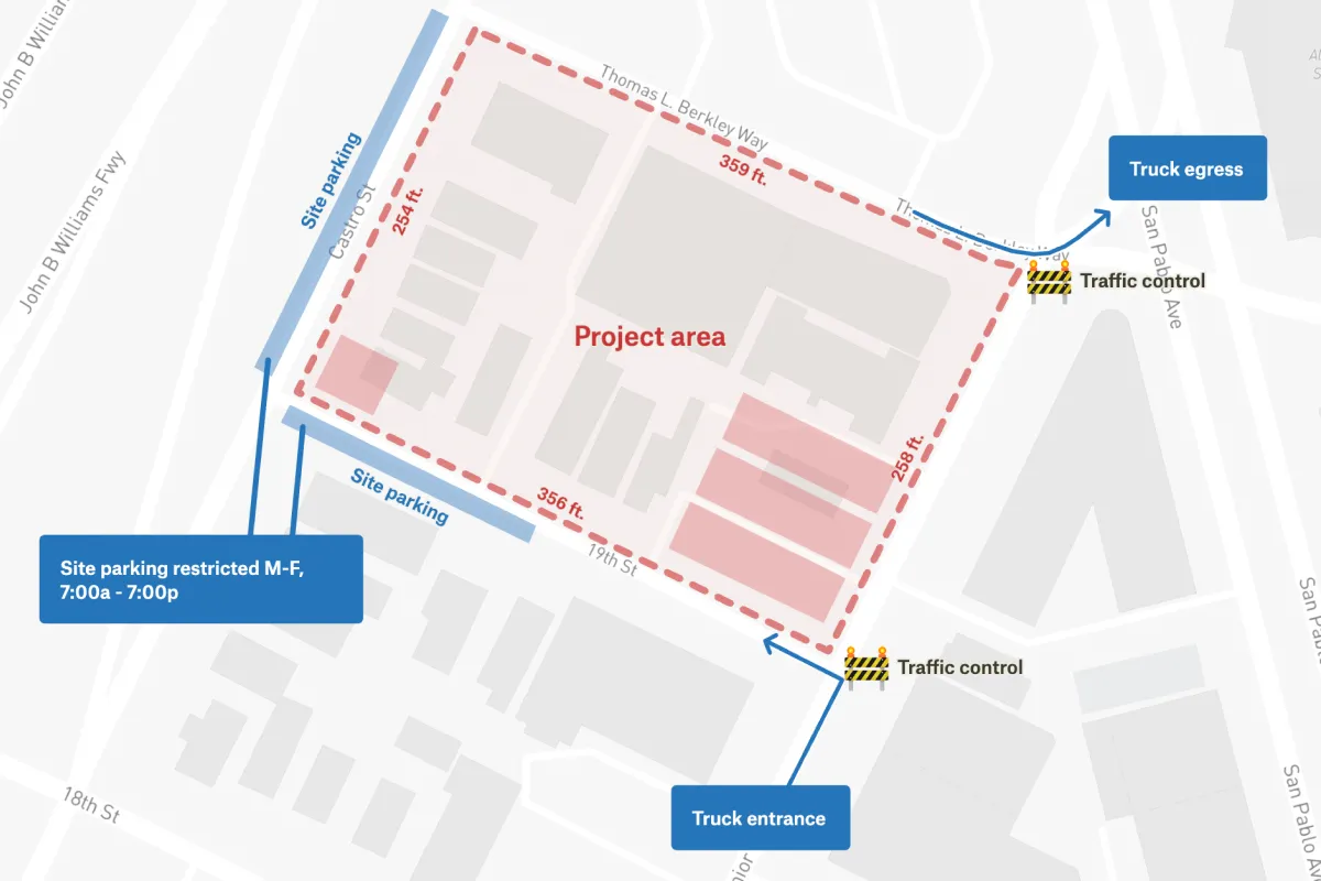
All Felt web traffic is encrypted via TLS, user credentials are stored with encryption at rest, all data is stored in the U.S., and we monitor DDoS activity and uptime 24/7.

More on security here →

Strong access controls

With Felt, your data stays yours. We build every map to be shareable, but with clear permission controls that let you choose exactly who can see your maps and when.

Learn more →
See what people everywhere are making with Felt
Customer Spotlight
"My favorite maps have always been the ones made in the moment, either out of necessity or on a whim."
— Tim wallace, senior editor of geography, new york times
"My favorite maps have always been the ones made in the moment, either out of necessity or on a whim."
— Tim wallace, senior editor of geography, new york times
Start creating maps today