37° 48' 15.7068'' N, 122° 16' 15.9996'' W
MODERN MAP MAKING HAS ARRIVED
37° 48' 15.7068'' N, 122° 16' 15.9996'' W
MODERN MAP MAKING HAS ARRIVED
37° 48' 15.7068'' N, 122° 16' 15.9996'' W
MODERN MAP MAKING HAS ARRIVED
37° 48' 15.7068'' N, 122° 16' 15.9996'' W
MODERN MAP MAKING HAS ARRIVED
37° 48' 15.7068'' N, 122° 16' 15.9996'' W
MODERN MAP MAKING HAS ARRIVED
37° 48' 15.7068'' N, 122° 16' 15.9996'' W
MODERN MAP MAKING HAS ARRIVED
37° 48' 15.7068'' N, 122° 16' 15.9996'' W
MODERN MAP MAKING HAS ARRIVED
37° 48' 15.7068'' N, 122° 16' 15.9996'' W
MODERN MAP MAKING HAS ARRIVED
37° 48' 15.7068'' N, 122° 16' 15.9996'' W
MODERN MAP MAKING HAS ARRIVED
37° 48' 15.7068'' N, 122° 16' 15.9996'' W
MODERN MAP MAKING HAS ARRIVED
Maps
Modern client collaboration: Alta Planning + Design case study
Alta Planning+Design, a leading consulting firm specializing in bicycle and pedestrian planning, is using Felt to bring their clients a more modern mapping experience.

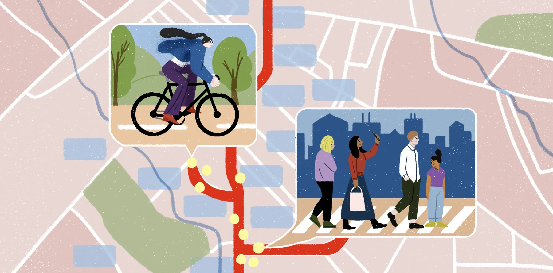
Alta Planning + Design is an international consulting firm with a mission to create active communities where bicycling and walking are safe, healthy, fun, and normal daily activities. Philip Longenecker is a Portland-based Planner at Alta working on a range of projects. When working on a new project, Philip usually starts with technical research and spatial analysis using GIS and R, evaluating alternatives and providing data driven recommendations. Then he goes into mapping and visualization of possible solutions for clients and evaluating policy priorities for allocating space in the right-of-way to support multi-modal transportation.

To be successful, Philip needs to get inputs from his coworkers, the firm’s clients, and local communities. Before discovering Felt, he struggled with finding the right tool that would allow him to collaborate seamlessly with multiple stakeholders. Now Felt allows him to host remote workshops, run client presentations, and collect his research insights in one place.

Remote collaboration with clients and stakeholders

Alta Transportation Planner Philip Longedecker used Felt to host a virtual charette for the City of Tigard. Due to Felt's ease of use, the effort resulted in a rich discussion and valuable feedback that could be exported as geojson objects for post processing.

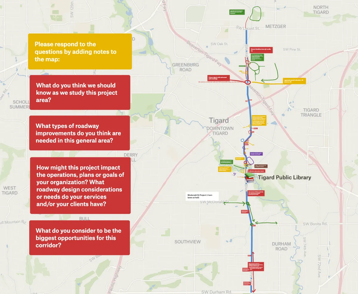
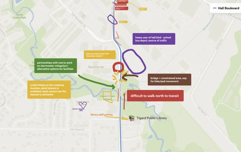
When working on a transportation project for the City of Tigard, OR, the team needed to get input from several community focus groups remotely. Philip was looking for a tool to host virtual design charrettes – events where stakeholders can collaborate and draw notes together in real-time, without the need for printed maps or being in the same room. He tried using other collaboration tools but they just didn’t work well for maps. Felt's platform, which is both simple to use and enables synchronous collaboration, was the perfect solution.

Philip outlined a project area on a map and invited ten people to collaborate on it. His stakeholders used notes to add the community’s feedback about driving conditions, as well as opportunities for better crossings, green infrastructure, and enhanced bus stops. These insights helped Alta team members to get necessary context to develop their proposal for road improvements. “Felt allows us to have really productive dialogue remotely,” Philip shared of the experience.

Smooth sharing with clients & teammates

Being able to view and manipulate data is crucial in infrastructure planning. However, viewing data, especially spatial data can be a challenge. In fact, “very few of our clients have the ability to open shapefiles, geoJSON, or other types of spatial data files,” says Philip. Felt solves that problem by both making it easy to upload files of all formats, and to share the results with a single link visible through the browser. "Felt's platform allows our clients to view and work with data, without needing expensive desktop software."

Ease of sharing combined with the accessibility of the platform allows Philip to work more easily with a broad range of clients who may or may not need a full-blow GIS system on a day to day basis. For example, Philip’s team wanted to give a small bikeshare non-profit a suitability index for new bikeshare stations, but there wasn't a way to share a large citywide map that non-technical people could work with easily. In this case, sharing the dataset via Felt helped since the nonprofit team didn’t need a subscription to any professional GIS tools to access it.

Felt's platform allows our clients to view and work with data, without needing expensive desktop software.

On the same page, at every scale

Another common challenge facing Philip’s workflow is how to present maps in a way that captures the scope of the project but also allows for more detailed views. Traditionally, large maps are presented as flat file PDFs, whose size is limited by the paper it is presented on. To have a more dynamic conversation about a project covering the Island of Oahu, Philip's team decided to utilize Felt’s infinite map canvas. They symbolized the data to tell their story, and shared the project map with their client via a single link. Then, they were able conduct a lively and dynamic discussion while answering questions and capturing placed-based comments on the fly. “PDF maps just don't cut it. Being able to scroll around and zoom in on a dataset is extremely helpful,” shared Philip.

Faster decision-making

When it comes to planning cycling infrastructure, all decisions come down to space. Felt's combination of easy to use drawing and measurement tools allows Philip’s team to determine the feasibility of ideas on the spot. “While working on a project for the City of Lake Oswego, we could generate estimates for how much width we have for a bike lane,” Philip shared.

Philip found himself leveraging Felt again to quickly determine the feasibility of a corridor redesign project . He uploaded traffic flows data and sketched out different turning movements using Felt’s drawing tools. Without switching to another program, the team could assess which of the different options could fit within the available space and determine the likely pinch points.

Accelerating research & insights

Philip kept all his notes in Felt to make sure he doesn't miss on any critical details.

Working on projects for both Lake Oswego and Tigard, Philip used Felt not just as a tool for workshopping ideas with stakeholders, but as a place to document his own research insights. Up until delivering the report for redesigning traffic corridors in both cities, Felt was a living document where Philip kept his notes, ideas, and sketches. It has been helpful to be able to paste images of plans from previous reports right onto the map to follow planning recommendations that have already been made. Philip then exported key elements created in Felt as geoJSON so they can be opened in ArcGIS Pro and used for creating PDF or web maps that go into the final version of the report.

An indispensable tool

Overall, Felt is an indispensable tool for infrastructure planning. Felt handles all data formats a planner works with, intuitively presenting the data as you need it, with no extra input or confusing questions. Its ease-of-use makes it the perfect tool for collaborating with project teams and clients of all backgrounds. The ability to share projects in the browser without any other desktop software is a game changer for how teams can incorporate maps into their workflows. By solving these long standing pain points, Felt is changing the way we use maps to be more effective and efficient (and more fun). Try it today or reach out to our team for a demo.

PDF maps just don't cut it. Being able to scroll around and zoom in on a dataset is extremely helpful.
Bio
LinkedIn
More articles

Cartography Tips for Designing Web Maps

Search, filter, select — data discovery done right

Getting the most out of Felt’s new Workspaces

Teaching Spatial Analysis with Felt

Powerful new admin tools and a streamlined billing experience

Three key UI upgrades in Felt 2.0