37° 48' 15.7068'' N, 122° 16' 15.9996'' W
MODERN MAP MAKING HAS ARRIVED
37° 48' 15.7068'' N, 122° 16' 15.9996'' W
MODERN MAP MAKING HAS ARRIVED
37° 48' 15.7068'' N, 122° 16' 15.9996'' W
MODERN MAP MAKING HAS ARRIVED
37° 48' 15.7068'' N, 122° 16' 15.9996'' W
MODERN MAP MAKING HAS ARRIVED
37° 48' 15.7068'' N, 122° 16' 15.9996'' W
MODERN MAP MAKING HAS ARRIVED
37° 48' 15.7068'' N, 122° 16' 15.9996'' W
MODERN MAP MAKING HAS ARRIVED
37° 48' 15.7068'' N, 122° 16' 15.9996'' W
MODERN MAP MAKING HAS ARRIVED
37° 48' 15.7068'' N, 122° 16' 15.9996'' W
MODERN MAP MAKING HAS ARRIVED
37° 48' 15.7068'' N, 122° 16' 15.9996'' W
MODERN MAP MAKING HAS ARRIVED
37° 48' 15.7068'' N, 122° 16' 15.9996'' W
MODERN MAP MAKING HAS ARRIVED
Maps
Product
How one engineering firm streamlined client feedback with the 'Add to Felt' QGIS plugin
ICON Engineering, Colorado-based firm specializing in stormwater and transportation engineering, is leveraging Felt and QGIS for getting stakeholder feedback faster.

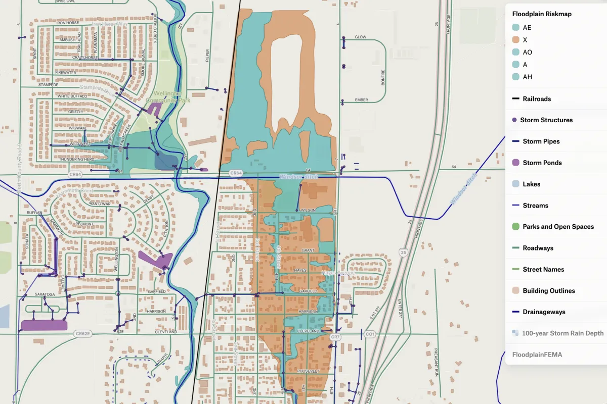
Josie Steffens, the Design Engineer at ICON Engineering, a civil consulting firm in Denver, Colorado, works with multiple clients, mainly providing floodplain analysis and master planning. Her team focuses on working with local city governments and municipalities, but they also work with smaller clients, contractors, and construction crews.

Josie uses QGIS every day because she loves its modeling features, like Hydrologic Engineering Center River Analysis System (HEC-RAS), and prefers it to all the paid alternatives. HEC-RAS is super powerful, but sharing the results is hard—it would require her stakeholders to open the model on their own desktop, or wait until the end of the project to provide feedback. The ‘Add to Felt’ plugin solved this issue. With the plugin, Josie can easily get her QGIS results on the web, where they can be shared with clients and teammates for feedback and coordination.  ‘Add to Felt’ has become a permanent part of her mapping stack.

Seamless team collaboration

ICON Engineering has 3-4 people focused solely on GIS projects. Typically, the team works on all the projects together, integrating feedback as the project evolves. "Felt helps us keep each other updated on what we've done, what we've modeled, how things are progressing," says Josie. It also allows her to speed up approval process and get her manager's input without them looking into the HEC-RAS model—now they just share a link to a Felt map, which appears quickly and simultaneously  in their browsers.

An example of a final deliverable that shows where the floodplain is within an area and what roads/houses/and pipe infrastructure are impacted.

Collecting critical client input earlier, and more often

Before Felt, Josie struggled to find the optimal way to present her work to clients. The only way for her to get feedback was to share a HEC-RAS project file with those who have the background knowledge to review its contents, but it didn't allow her to check in with other important stakeholders.

"I was looking for a user-friendly online product for the clients so that they can see what we've modeled and have everything at their fingertips," says Josie. This process has become particularly crucial as many of the clients are local government officials and do not have a GIS background or access to professional GIS tools.

"Felt helps us keep each other updated on what we've done, what we've modeled, how things are progressing."

Felt also provides a way for Josie to conduct frequent check-ins with clients to ensure that everything is up to their standards. "There wasn't a good way of providing anything to the client throughout the project; we only had a final deliverable. Felt allowed us to do more frequent check-ins with the client," adds Josie.

Recently, she has been working with clients in Brighton, Colorado, and building a hydraulic model of the entire basin for them. She regularly updated shapefiles in QGIS, then uploaded them to Felt, and then sent a link to the clients so they could make sure that the routing was up to their standards. "The prior process was just sending an email whenever we had questions or maybe a few meetings here and there, but with Felt, we're getting valuable feedback from the client every other week," says Josie.

More than a map: links, photos, and drone videos all in one place for the client

Currently, Josie mainly works on projects related to floodplain analysis and master planning, but the possibilities for maps are endless, particularly company-wide. She has been exploring the use of Felt to create more high-fidelity deliverables and building final story map.

She has found that by using Felt, she can build on top of exported QGIS layers and offer clients all the information they need, which may include relevant links, photos, and drone videos of construction sites over time. Felt provides great additional context so clients can see what's happening and understand why certain decisions have been made.

Overall, Felt has provided a new way for Josie and her team to communicate with clients, create more high-fidelity outcomes, and work more effectively as a team. The use of Felt has allowed for more collaboration, and the ease of use has allowed for clients to be more involved in the project and more confident in the outcome.

"There wasn't a good way of providing anything to the client throughout the project; we only had a final deliverable. Felt allowed us to do more frequent check-ins with the client."
Bio
LinkedIn
More articles

Cartography Tips for Designing Web Maps

Search, filter, select — data discovery done right

Getting the most out of Felt’s new Workspaces

Teaching Spatial Analysis with Felt

Powerful new admin tools and a streamlined billing experience

Three key UI upgrades in Felt 2.0