Build Maps & Dashboards with PostGIS (PostgreSQL Extension): A Step-by-Step Guide
Sri Vemuri
,
Product Marketing
•
Thursday, August 1, 2024
Connect your PostGIS database directly to Felt to map your location data.
Connect your PostGIS database directly to Felt to map your location data.
In the world of geospatial data management, PostGIS has long stood as the industry standard. As an extension to PostgreSQL, PostGIS brings robust spatial capabilities to one of the most powerful open-source relational database systems. Its ability to handle complex spatial queries, store various geometric types, and process large datasets has made it an indispensable tool for GIS analysts, urban planners, and data scientists alike.
At Felt, we're committed to pushing the boundaries of what's possible in geospatial technology. Our modern cloud-native GIS platform has been continuously evolving, introducing features that make mapping and spatial analysis more accessible and powerful than ever before. We're thrilled to announce our latest update: direct integration with PostGIS databases.
Getting your PostGIS data–from Shapefiles to GeoJSON–into Felt is now easier than ever. Here's how you can set it up in just a few steps:
Create a new, read-only user on your PostGIS database for Felt access.
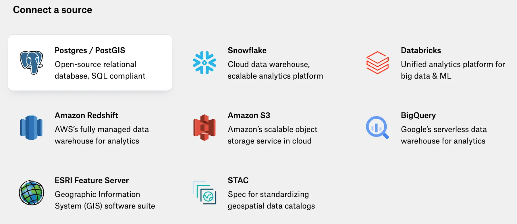
In Felt, click on the Library in the toolbar.
Click "+ New Source" and select "Postgres / PostGIS".
Enter your connection details, including host, port, database name, and credentials.
Click "Connect", and voilà! You'll see a catalog of your data with previews.
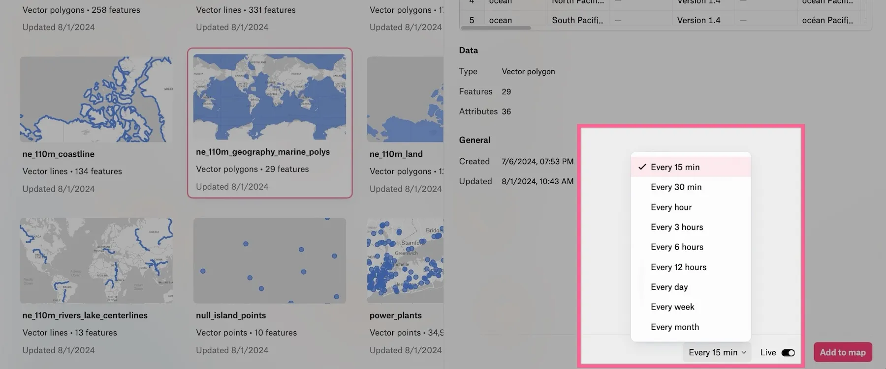
Make it live from the layer preview at a refresh cadence of your choice, or on-demand from the map view.
Preview Live Layers and Auto-Refresh Data from your Database 📡
Once connected, preview live layers right within Felt. You can easily add any of these layers to your spatial dashboards, bringing your database and vector data directly into your Felt workspace. Your data stays up-to-date and linked to your source of truth.
Unleashing the Power of Your Spatial Data with Components
But we didn't stop at just connecting your database. Felt's integration with PostGIS unlocks a whole new world of possibilities for your location data, including our powerful Components feature. Components allow you to create interactive and informative dashboards that bring your PostGIS data to life.
By building a PostGIS database to connect with Felt, geospatial analytics firm Terrabotics rapidly accelerates development time–from weeks to minutes–updating client maps.
A Sales Dashboard in Felt Powered By PostGIS Data 📈
Here's what you can do:
Statistic Component: Quickly summarize numeric values into essential metrics. Whether you need to show the count of features or calculate sums, averages, minimums, maximums, or medians, this component provides instant insights.
Bar Chart Component: Visualize and compare categories effortlessly. Perfect for comparing sales performance across different regions or visualizing user demographics.
Histogram Component: Identify data patterns and trends by displaying frequency distributions. Great for understanding the spread of data points, such as age distributions or elevation profiles.
Filter Component: Drill down into your data with on-the-fly filtering. Use dropdown menus for categorical data or sliders for numeric ranges, allowing users to focus on the most relevant information.
Time Series Component: Explore spatial trends over time with an intuitive time slider. Ideal for tracking changes in your data across different time periods, from hourly traffic patterns to yearly temperature variations.
Unlike business intelligence tools like Tableau, Felt’s Components were built from the ground up to handle spatial data analysis. These components work seamlessly with your PostGIS data, updating in real-time as you pan and zoom your map or apply filters. This dynamic interaction between your database and Felt's visualization tools opens up new avenues for insight and decision-making.
More Than Just a Connection
Built to Fit Any PostGIS Workflow 🌎
Our PostGIS integration is designed to make your workflow as smooth as possible:
Live Data Updates: Keep your maps, dashboards, and components in sync with your database. Set up automatic refreshes or update on demand.
Geomatching and Geocoding: Leverage Felt's advanced features to enrich your PostGIS data, matching geometries or adding location data to your tables.
Collaborative Mapping: Share your PostGIS layers and interactive dashboards with your team, fostering cloud collaboration from anywhere and insights across your organization.
Automatic Field Population: Felt intelligently populates fields based on your PostGIS data structure.
Granular Access Control: We're working on an allowlist feature to give you fine-tuned permissions over who can access your PostGIS data within Felt.
QGIS Integration: Already have your PostGIS data visualized in QGIS? Bring QGIS maps over to Felt with the plugin, retain your QGIS styles, and collaborate in the cloud from anywhere.
Extendable API: Use Felt’s API to accelerate your PostGIS workflows. Update layers programmatically, take advantage of webhooks to trigger actions in your PostGIS database, leverage the Python SDK, and more.
By bringing PostGIS and Felt together, we're creating a powerful ecosystem for spatial data analysis and visualization. Whether you're a city planner working with infrastructure data, a researcher analyzing environmental patterns, or a business intelligence expert mapping market trends, this integration makes it possible to visualize complex spatial datasets and bring together project stakeholders.
Ready to supercharge your spatial data analysis? Database connections are available today on our Enterprise plans. Contact our sales team to learn more about how Felt's PostGIS integration can transform your workflow.
"Live dashboard updates allow us to be efficient by looking at where our pickup requests come in." – Michelle Denna, VP of Sales, Sharetown