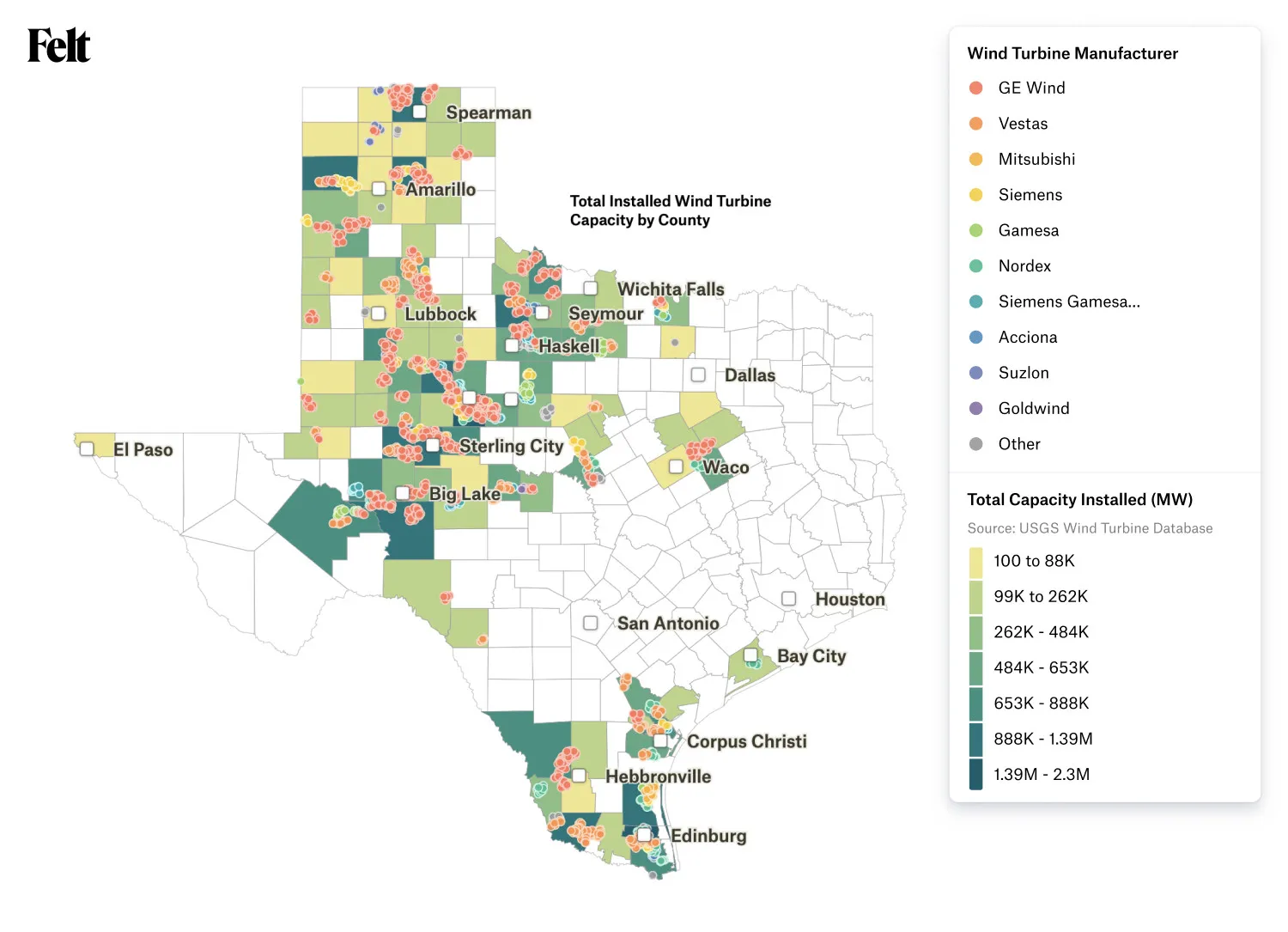
Easily bring data to Felt with our QGIS plugin and the Felt API
Michal Migurski
,
Data Products
•
Wednesday, June 21, 2023
Creating collaborative maps is now even faster, with three new ways to bring data directly into Felt: a QGIS plugin, Open in Felt buttons, and the Felt API.
Creating collaborative maps is now even faster, with three new ways to bring data directly into Felt: a QGIS plugin, Open in Felt buttons, and the Felt API.
Felt is the best tool for teams to visualize, share, and collaborate on geospatial data — and the first step to successful collaboration is bringing the right data into your maps.
Our most active users have consistently asked to supercharge Felt’s ability to read their data from other libraries or custom workflows. Today, we are announcing a brand new set of features to make it easier and faster to bring your data into new Felt maps:
QGIS users can create Felt maps directly from QGIS projects with the new QGIS plugin.
Data publishers can easily provide a place for customers to visualize purchased data by adding an Open In Felt button.
Organizations can more easily integrate Felt into team workflows with the new Felt API.
With the new open-source QGIS plugin, expert QGIS users can quickly export their projects to new maps in Felt for easier sharing and collaboration with colleagues online.
You can turn your QGIS project into a Felt map directly from your Web toolbar in QGIS.
QGIS projects are complex, single-computer desktop experiences, often with dependencies on large directories of files or privileged access to remote data services. Felt now allows these projects to live on the internet with sharing, team permissions, and channels for feedback and responses.
Once your map is in Felt, you can style, share, and collaborate in real time.
Want to know more about Felt?
Learn all you need to know watching this 2 minute video or book a demo with our team.
It’s common for Felt users to create maps that connect local project data with background context data sourced from publishers or other organizations. Until today, users who’ve used data from online sources needed to download and upload entire files locally. We are now making it possible for any dataset publisher to add an Open In Felt button to make this a single-click operation that saves the user bandwidth, time, and hassle.
The button is easy to integrate, often requiring just a link and a publicly viewable URL for any data source currently compatible with Felt. When users click the button they will be prompted to create a new map and import the data referenced in the url:
These buttons can be created by any user and attached to any source of data. Does your organization host a directory of downloadable shapefiles? Do you make GeoJSON available from a Github repository? Do your shared spreadsheets have geocodeable address data they can map in Felt? Create a simple HTML Open In Felt button and give your non-technical users the single-click ability to create maps for visualization, sharing, and collaboration. For trusted partners, you can have your brand featured inside the product, and give customers confidence the data they are importing is authentic.
Regrid & Felt
Speaking of trusted partners, we’re excited to announce our partnership with Regrid, the leading provider of high-quality land parcels and location context data for creative maps, innovative apps, and insightful spatial analysis. Regrid uses the Open In Felt button to give their users a faster way to view their purchased data in Felt. Parcel files from Regrid can include hundreds of columns of detailed information and be multiple gigabytes. Regrid’s users can now effortlessly integrate those files into Felt workflows without needing to handle large GIS files directly. To learn more, check out Regrid’s blog post about our partnership.
The Felt API for Integrated Workflows
The new plugin for QGIS users and the Regrid Open in Felt button have something in common: they’re both enabled by our powerful new Felt API, which exposes programmatic data uploading functionality to anyone needing to script and automate additions to Felt.
Many of our users have wanted to set up scheduled tasks and integrations between their data and Felt. Our new API now makes this easy and safe for developers. We’ve made several key functions accessible via our new web API:
Create a new Felt map
Upload data from files or URLs to new layers in a Felt map
Retrieve user-created elements from a Felt map
These first three functions make it possible to use Felt as part of a larger mapping workflow. Our users have asked about automatic uploads on a set schedule, such as weekly or hourly updates to fast-moving datasets. It's as simple as:
Which returns:
Users can now create new maps and data layers from unattended scheduled tasks in their cloud applications, make that data available for annotation, improvement, or feedback, and pull those additions back into their systems by requesting map elements as GeoJSON.
The API is securely protected via OAuth authentication and personal access tokens to ensure that Felt actions are run only by authorized users. Read our developer documentation to get started.
Just the Beginning
We know that today’s new features will make it easier than ever for users to integrate Felt into their work. But what we don’t know is exactly how you’ll use these new features — and we we’re so excited to see what you’ll build!


.webp)