What is a forest survey? Facilitating forest management
Forests are some of the most complex ecosystems on the planet. They support a vast diversity of plants, animals, and microorganisms while also providing essential resources for humans. Effective forest management helps managers understand and sustain these dynamic systems.
Whether the goal is environmental protection or timber production, forestry surveys reveal what’s happening beneath the forest canopy. By tracking changes over time and observing how different areas respond to management, scientists, surveyors, and planners can make smart decisions that balance ecological needs with economic goals.
In this guide, we’ll explore the importance of surveying in forest management and different types of surveys. We’ll also look at how Felt’s cloud-native, AI-powered GIS platform visualizes data to facilitate long-term planning and sustainable resource use.
Key aspects to understand: How is surveying used in forestry?
Forestry surveys provide a precise picture of the land. They include mapping tree species, topographic features, and property lines. This allows managers and landowners to track changes over time and plan for sustainable harvesting or preservation.
Let’s take a closer look at the questions field surveying can answer.
Land mapping
Land mapping measures a property’s physical characteristics, boundaries, and uses. Surveyors use it to classify land into various categories, such as forested areas and cleared timber zones. With this data, managers can plan for harvesting or conservation work.
Forest Health Monitoring
The U.S. Forest Service runs the national Forest Health Monitoring program. It assesses changes in ecosystems to determine if a forest’s overall health improves or declines over time.
The program measures several indicators of overall forest health, including tree mortality, soil health, and damage from fire and pests. Forest Health Monitoring data is publicly accessible, empowering policymakers and land managers to make better decisions about sustainable forest management.
Northern Arizona University and Felt collaborate to monitor plant stress
Here’s a look at how Northern Arizona University used Felt to bypass a year of custom development and maintenance work and get straight into mapping and analysis. This shift didn’t just streamline the process. It helped save the state over $200,000 in consulting fees:
EcoMonitor Arizona, supported by the Technology Research Initiative Fund, developed a real-time system to monitor plant stress across Arizona. The team combines raster data (Planet SuperDove, Sentinel 2, Landsat, ECOSTRESS), ground observations, and advanced modeling techniques to continuously assess vegetation health.
For every 3-meter pixel in Arizona, the system tracks daily changes and calculates a custom stress index. This analysis identifies early signs of drought, pest infestations, and disease, enabling the Arizona Department of Forestry and Fire Management (DFFM) and the public to take targeted preventative actions and better plan for wildfires.
Infrastructure planning
Land surveying reveals where roads, trails, and fire routes should go without significantly impacting forest health. This helps managers maintain access for operations and firefighting while protecting from erosion and habitat loss.
Land boundary definition
Geospatial mapping reveals exactly where one property ends and another begins. This gives landowners and managers the confidence to plan harvesting, conservation, or recreational activities without crossing legal lines. Clear boundaries prevent disputes and support responsible, coordinated management.
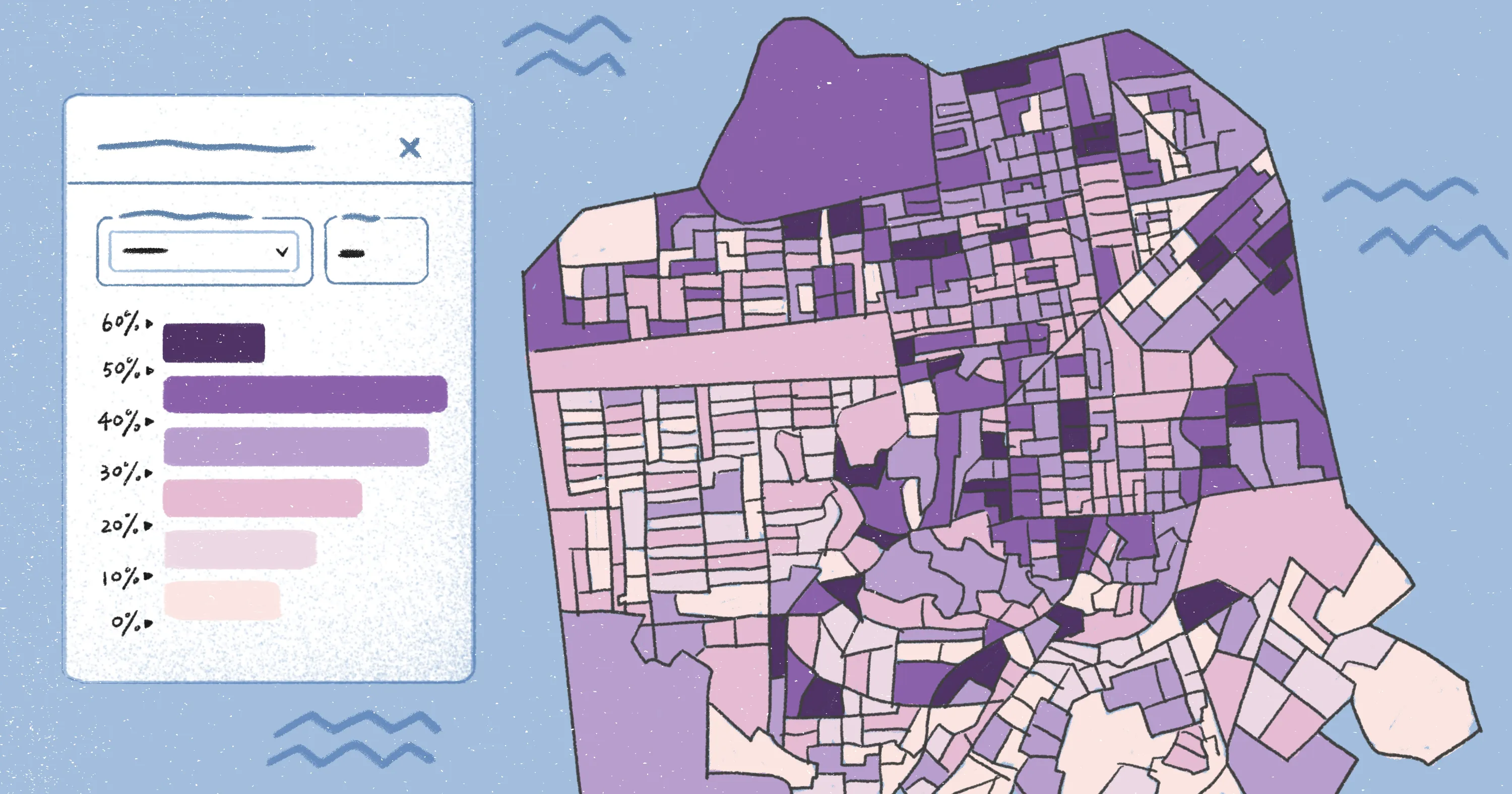
To fully understand and analyze the dynamics of a forest, surveyors rely on geographic information systems (GIS). GIS platforms like Felt turn complex data into visual maps that illustrate vegetation, growth, and land use patterns over time. Felt also supports high-resolution raster data so teams can work directly with satellite imagery and other remote sensing layers.
This creates a connected workflow. Field crews capture observations on the ground while teams in the office review imagery and update maps in real time. The result is a shared, accurate picture of forest conditions that support sustainable resource management and long-term forest health.
What are the four types of forest surveys?
Forests are living, breathing systems that change constantly. They respond to environmental pressures and human activity. Forest surveys capture these dynamics, giving land managers a clear understanding of how forests evolve.
Each type of survey offers a different perspective, helping surveyors make decisions that balance conservation, land use, and urban planning. Let’s take a closer look at four common land survey methods used in forest management:
1. Forestry inventory
A forestry inventory measures the number, size, and species of trees across a defined area. This information allows forest managers to spot growth patterns and anticipate future needs.
An environmental scientist might use this data to track biodiversity and monitor areas that need protection, ensuring habitats remain healthy. A timber company might use a forestry inventory to estimate timber volume and plan operations without depleting resources or harming sensitive areas.
2. Detection surveys
Insects, diseases, and other natural stresses can quickly threaten tree health if left unchecked. Detection surveys focus on tracking these issues with aerial and ground observations the U.S. Forest Service collects.
These surveys help to “determine detrimental changes or improvements that occur over time.” The Forest Service releases the data annually, giving state, private, and federal agencies detailed information to protect forests.
3. Regeneration surveys
After a section of forest has been harvested or affected by a natural disturbance, regeneration surveys identify where young trees have been planted and how well they’re doing. An environmental scientist might use this information to ensure habitat recovery, while timber companies rely on it to calculate future harvests.
4. Urban forest inventories
Trees play a vital role in urban environments, providing shade and improving air quality. Urban forest inventories gather detailed information about species, sizes, and health. This information helps urban planners plan maintenance budgets to care for a city’s tree population.
Capture how the forest changes with the Field App
Once upon a time, forestry surveys were painstakingly manual, requiring teams to record field data on paper and spend hours back in the office digitizing information. Today, surveyors rely on field data collection apps that make data tracking faster, more accurate, and easier to analyze.
Field App gives teams a powerful mobile GIS experience, allowing them to capture and edit data directly in the field. You can access maps and dashboards from anywhere, and automatically sync changes when you’re back online.
By keeping teams connected with up-to-date data, Field App makes it easy to track forest health over time. Crews can record inventory measurements for forestry inventories and document on-site findings during detection surveys. It gives teams a simple way to confirm regeneration progress and update urban tree conditions as they move.
Start with a free trial today and see how powerful field collection is made effortless with Field App.
FAQ
Who performs a tree survey?
Forestry professionals, urban planners, and environmental scientists perform tree surveys. Field technicians examine details like tree health and measure growth, providing insights needed to make informed decisions about conservation and resource management.
How do surveyors work around trees?
Surveyors navigate carefully through forest terrain, taking precise measurements while avoiding harm to roots, branches, and natural habitats. Digital tools like LiDAR, which sends laser pulses to map terrain and measure tree size, can help capture detailed forest data without disturbing the environment.
What is a vegetation land survey?
A vegetation land survey identifies plant types, density, and location. They’re used for several reasons, like identifying sensitive habitats that require protection during development projects or to design and track a restoration plan.
Compare Felt using AI