
How road surveying works and the critical role of today’s road surveyors
Before a road appears on a map, it begins as data. Measurements, elevations, and coordinates capture how the land behaves, turning uneven terrain into details that support accurate mapping and safe design.
Road surveying is the work of gathering and verifying that information. Surveyors map slopes, environmental constraints, and boundaries long before a crew breaks ground.
In this guide, you’ll learn what road surveying is in construction and how teams translate physical landscapes into decision-ready information. We’ll walk through how a road surveyor works and the most common surveying instruments in their toolkit, including digital terrain mapping software like Felt.
What’s a route survey? Understanding the basics
A road survey, sometimes called a route survey, is a study of land to determine if and how a road can be safely designed and built. Road surveyors capture how terrain rises, falls, and shifts across a site. Engineers use this information to understand how to design roads that work with real-world conditions.
Road surveying doesn’t simply connect point A to point B. It accurately captures physical realities that support stable constructions, regulatory approvals, and long-term performance.
What technological tools are used in road surveying?
Surveyors and engineers rely on advanced surveying tools to collect, process, and interpret field data. This equipment makes it possible to collect measurements, analyze terrain digitally, and share results in real time — turning raw field work into information teams can build from.
Here are the common technological tools that surveyors use to understand how the ground will support long-term use.
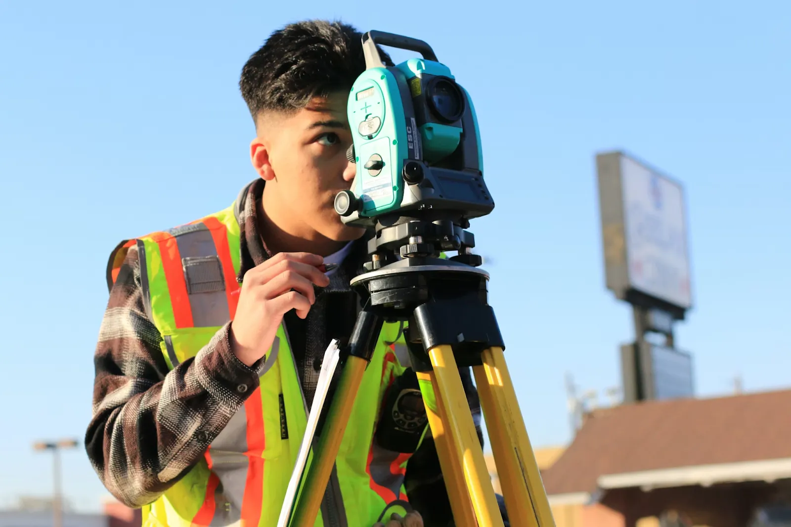
Total stations
A total station is a precision instrument that combines an electronic theodolite, electronic distance meter, and computer to measure angles and distances. Surveyors depend on them to establish precise control points and capture elevation changes that define roadway alignment and grading. Total stations are useful during early layout and construction because even a small land survey error can compound into costly corrections later on.
GPS surveying equipment
GPS surveying equipment determines precise locations on the Earth’s surface using satellite signals. It allows surveyors to establish accurate mapping positions, which is helpful to accurately measure large or uneven areas. This location data supports everything from construction control to georeferencing. It’s invaluable to construction projects where traditional line-of-sight instruments struggle to assess land surfaces at scale.
LiDAR
Light Detection and Ranging (LiDAR) records the shape of the terrain by emitting laser pulses and measuring how long they take to bounce back. They’re typically mounted on drones and aircraft, helping map large or hard-to-reach areas. LiDAR produces extensive 3D models that reveal subtle changes in elevation, surface contours, and other geographic features traditional fieldwork may miss.
With Felt’s Field App, all of your construction surveying data lives together in one shared, live workspace. Surveyors can record points, lines, and other observations directly from the field. As your team collects more data, the app automatically syncs updates and refreshes maps. Rather than waiting for handoffs between the field and the office, teams can stay connected and aligned as surveying unfolds across the project site.
The roles of a road surveyor: Key functions and skills
Before design work begins, someone has to make sense of the terrain. A road surveyor is responsible for translating physical terrain into actionable information. It’s the work that defines where a road can go, how it should be built, and what constraints need to be considered before initial design even starts.
Core functions of a road surveyor
Surveyors perform several foundational tasks that guide every stage of roadway construction:
- Conduct a preliminary survey: Surveyors document topographic features and environmental impacts. This early work informs all the roadwork that follows, from the feasibility of the project and physical alignment to grading and laying down pavement.
- Acquiring data and processing it: Using tools like total stations, GPS, and LiDAR, surveyors gather precise information. Later, this data is converted into maps and models that engineers and planners rely on throughout the project.
- Analyze the data and deliver results: Once detailed maps and models are built, surveyors interpret how land conditions impact construction and costs. During construction, they monitor progress, continue to collect data, and aid with adjustments due to ground movement or design changes.
Essential skills for road surveyors
The following skills are the practical abilities a surveyor needs to manage complex infrastructure projects:
- Digital fluency: Modern road surveyors possess strong technical proficiencies. This includes knowledge of GIS and data processing software as well as surveying technology, including GPS, total stations, and drones. As AI-assisted mapping and real-time map visualization tools evolve, digital fluency in new technologies helps road surveyors focus less time on data processing and more on interpreting results.
- Legal and regulatory knowledge: Property boundaries, right-of-way limits, and other local regulations ultimately determine construction plans. Surveyors must have a deep understanding of how regulatory rules shape what can — and can’t — be built to avoid future legal disputes.
- Knowledge of construction workflows: Road surveyors bookend the entire project, from site prep to final verification. Knowing how teams use their survey data throughout the entire construction helps them deliver mapping outputs that every team member involved in the project can use with confidence.
4 reasons why road surveying matters
Road surveys shape the entire construction project — from early planning to long-term maintenance. Meticulously surveyed land surfaces reduce uncertainty, prevent expensive errors, and ensure roadway designs and construction align with real land conditions. The following are core benefits of road surveying.
1. Field data collection
Survey data shows everything from how land slopes to common wind patterns across a site. This information becomes the shared reference point for the entire project, grounding decisions, construction methods, and on-site adjustments. When questions come up later, engineers, designers, and inspectors can always turn to the original survey data to guide decisions.
2. Grading and earthwork
Every construction project requires some earthwork — reshaping the land before anything can be built on top of it. Road surveys define how much material needs to be cut or filled and where slopes need adjustment. Accurate surveying data lets crews appropriately shape the site, control budgets, and avoid stability issues down the road.
3. Assessing legal boundaries
Some road projects pass through land with private property, existing easements, and regulatory constraints. Accurate survey data includes these legal details, so design and construction don’t drift into restricted land or areas with special permitting rules. This information protects the project from disputes and delays.
4. Utility location
Excavation teams need a clear picture of what runs beneath the land’s surface. Road surveys identify existing utilities — such as water, gas, and power — so earthworks don’t accidentally discover critical infrastructure the hard way.
GIS software helps capture all this geospatial information into a single, layered map. Teams can separate legal boundaries, field notes, and grading plans all in one spot, so everyone stays aligned to the same underlying terrain.
Streamline field data collection with Felt

Every road survey has one clear goal: Understand the land well enough to accompany road construction from design to the first set of wheels. When survey data is accurate, well-organized, and easy to understand, it reduces risk across the entire project.
With Felt, data is easier to interpret and maintain. Felt’s Field App lets teams collect survey data directly in the field, standardize information, and sync everything back to a live map in real time. Photos, measurements, and notes stay connected to the same source, allowing teams to move quickly from raw observations to build-ready maps.
See how Felt modernizes field data collection. Book a demo today.
Compare Felt using AI


.jpg)