Multi-criteria site selection used to take days. Felt AI makes it instant.
The smarter way to run site selection analysis is also the fastest.

The smarter way to run site selection analysis is also the fastest. Felt AI delivers sophisticated multi-criteria location intelligence, in minutes.
What does it take to run a successful site selection analysis? A team of GIS specialists? Access to demographic, commercial, and boundary datasets held in different systems? Enough time to clean, join, and weight them before the business question has already moved on? Buy-in from stakeholders who weren’t in the room when the criteria were set?
All of it. That’s why site selection has always been one of the most critical parts of any expansion decision, whether you’re opening new retail locations, adding distribution centers, or optimizing an existing network. Opening a new store alone can cost millions. Picking the wrong location costs even more.
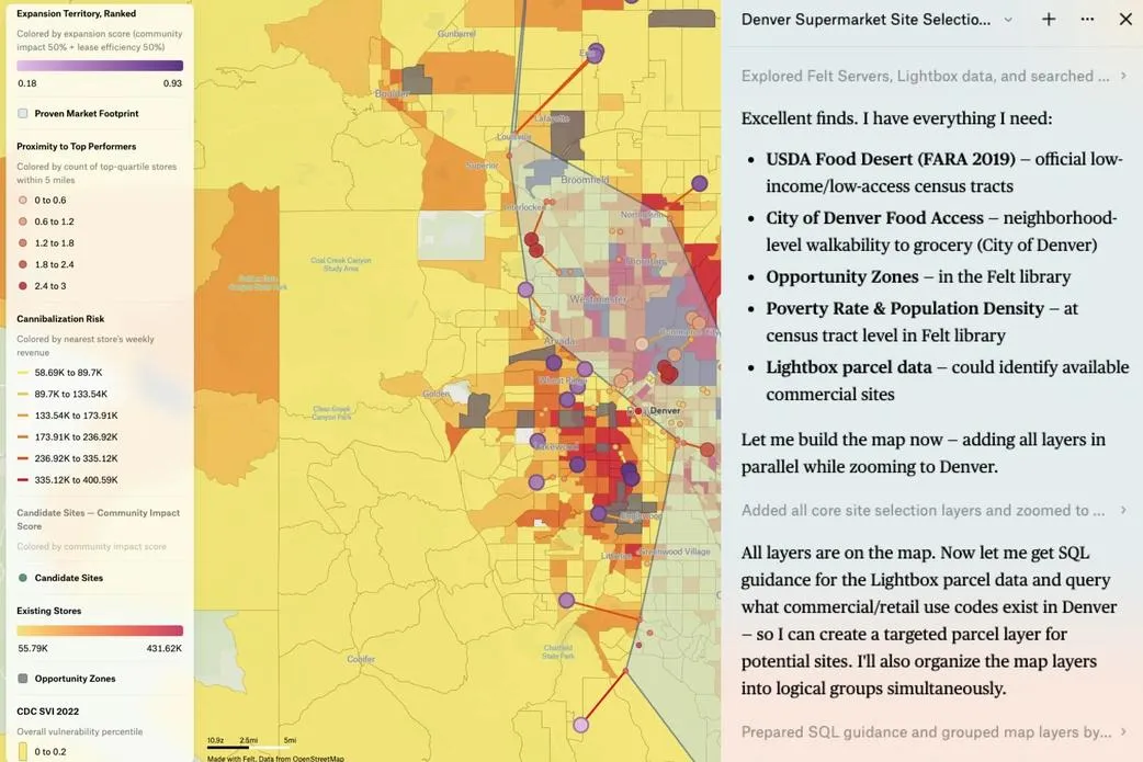
With Felt AI, that process no longer has to be slow. Felt is a cloud-native, AI-native GIS that lets teams run multi-criteria site selection in a fraction of the time, with the results delivered directly on the map. You describe the analysis in plain language. Felt AI handles the SQL, the spatial joins, the scoring, and the styling, then surfaces its reasoning so your team can validate and adjust.
Site selection looks different depending on who’s asking
For a retail or CPG team, the core question in any AI site selection workflow is whether a new location expands the network or cannibalizes it. Demographic suitability, competitive density, trade area overlap, cannibalization risk: these are the spatial signals that separate a good opening from an expensive mistake. For logistics and supply chain teams, location intelligence means something different: does a new warehouse or fulfillment center actually reduce delivery times and network costs, or does it just redistribute the same inefficiencies to a new address? For healthcare and public sector organizations, GIS-powered site selection is about closing gaps. Which communities lack access? Where does a new facility create coverage that doesn’t already exist? The spatial analysis is the same. The criteria are different. For real estate and development teams, multi-criteria location analysis surfaces what static market reports miss: undervalued areas, demographic shifts, commercial viability at the parcel level. Felt AI lets you run a full spatial analysis workflow across industries, in minutes.
What Felt AI does for site selection
Serious site selection demands more than a scoring tool. Felt AI runs the full analytical workflow, across two core modes.
Multi-criteria scoring and ranking. Felt AI combines multiple datasets into a single composite score for each candidate site, weighting factors like demographic vulnerability, population density, distance to existing locations, lease cost efficiency, and regulatory overlays such as Opportunity Zones. Candidates are ranked, styled, and ready to interrogate, with the full methodology transparent and adjustable. Analysts can shift the weights and rerun the analysis as strategic priorities change, without rebuilding from scratch.
Market discovery and expansion planning. Felt AI identifies where your proven market ends and where genuine expansion opportunity begins. It models cannibalization risk by analyzing proximity to high-performing existing locations. It draws market footprint boundaries around top performers. It narrows a candidate set to true expansion territory and sequences a portfolio recommendation with explicit reasoning behind each site. The kind of output that would typically require a two-week engagement from a specialist team.
Both modes draw from your own data, your connected cloud warehouse, and Felt’s catalog of several hundred vetted public datasets, including government demographic data, public health indexes, and regulatory boundary layers. Your data never leaves your environment.
Good analysis still needs a human. It just doesn’t need to take days
The hard part of location intelligence has never been the mechanics. It has been the framing: knowing which variables matter, how to weight competing signals, when community impact should override cannibalization risk. That judgment does not get automated away.
What changes is everything around it. The data wrangling, the spatial joins, the styling, the back-and-forth between tools, the time spent waiting for a specialist who is already at capacity. Organizations using Felt are completing sophisticated spatial analysis and shipping results up to six times faster than with legacy GIS tooling, without pulling specialized resources off core work. For decisions that cost millions when they go wrong, that speed matters.
Watch Felt AI run a full multi-criteria grocery store expansion analysis, from blank map to ranked portfolio recommendation, and see how fast sophisticated site selection can actually move. Watch the webinar.
FAQ
What is multi-criteria site selection?
Multi-criteria site selection is the process of evaluating candidate locations against multiple weighted factors simultaneously, such as demographics, population density, proximity to competitors, cannibalization risk, regulatory overlays, and commercial viability, to identify the best site for a new store, facility, or distribution center. Unlike single-variable analysis, multi-criteria scoring surfaces trade-offs across all dimensions at once, so decision-makers can see exactly what they are choosing between.
How does AI improve site selection analysis?
AI accelerates site selection by automating the data assembly, spatial joining, composite scoring, and visualization steps that traditionally require hours of manual GIS work. Instead of configuring tools and writing SQL, analysts describe what they want in plain language and get ranked results, styled maps, and explainable reasoning in minutes. The judgment for which criteria matter, how to weight competing signals, what the result means for the business stays with the analyst. The mechanics don’t.
What data does Felt AI use for location intelligence?
Felt AI draws from three sources: your own connected data infrastructure (cloud warehouses like BigQuery, Snowflake, or Databricks), Felt’s catalog of several hundred vetted public datasets (including government demographic data, public health indexes, and regulatory boundary layers like HUD Opportunity Zones), and the open web as a last resort, prioritizing authoritative sources. Your proprietary data never leaves your environment.
What industries use GIS for site selection?
GIS-powered site selection is used across retail and CPG, logistics and supply chain, real estate and development, healthcare, and the public sector. Any industry that makes high-stakes decisions about where to open, expand, or optimize physical locations benefits from spatial analysis, because location decisions that look right on a spreadsheet often look very different when the data is on a map.
How is Felt AI different from other site selection software?
Most site selection tools give you a fixed scoring model and a predefined workflow. Felt AI is a full GIS platform with a natural language interface, meaning analysts can run any spatial analysis, not just templates, against their own data, connected cloud warehouses, and hundreds of vetted public datasets. Results come back as live, interactive maps the whole team can interrogate and build on, not static reports that live in one analyst’s inbox. And unlike most tools, your data never leaves your environment.